Layers
A complete radar image is composed of several layers (listed in drawing order):
With the exception of the background fill color, each layer can be turned on and off individually.
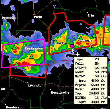
An additional layer is the tip window. It is enabled by selecting the Show Tips item from the View menu. When enabled, tip windows pop up over the radar display when the mouse cursor hovers over a storm attribute icon.
Right-click Context Menu
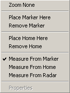
Right-clicking on the radar display shows the context menu.
Zoom None
Zooms out to maximum view width and centers the display on the radar site.Place Marker Here
Positions the temporary marker at the right-click location and automatically selects "Measure From Marker". The temporary marker icon appears as a small red or yellow square.Remove Marker
Deletes the temporary marker.Place Home Here
Positions the home location for the current site at the right-click location and automatically selects "Measure From Home". The home icon appears as a small red or yellow plus sign and persists on a per-site basis.Remove Home
Deletes the home marker.Measure From Marker
Sets the Measure From reference location to the temporary marker. The marker icon turns red to indicate it is being used as the reference. The azimuth and range from this marker to the mouse cursor is displayed in the status bar. In addition, the range rings are centered on the marker. This menu item is disabled if no temporary marker is set.Measure From Home
Sets the Measure From reference location to the home location. The home icon turns red to indicate it is being used as the reference. The azimuth and range from the home location to the mouse cursor is displayed in the status bar and the range rings are centered on it. This menu item is disabled if no home location is set.Measure From Radar
Sets the Measure From reference location to the current radar site. The radar icon, a small diamond, turns red to indicate it is being used as the reference. The azimuth and range from the radar site to the mouse cursor is displayed in the status bar and the range rings are centered on it.